SRI LANKAN MAP
- google map: Find Location

Anuradhapura Kingdom

Anuradhapura is a major city in Sri Lanka. It is the capital city of North Central Province, Sri Lanka and the capital of Anuradhapura District. Anuradhapura is one of the ancient capitals of Sri Lanka, famous for its well-preserved ruins of an ancient Sri Lankan civilization. It was the third capital of the Kingdom of Rajarata, following the kingdoms of Tambapanni and Upatissa Nuwara. The city, now a UNESCO World Heritage Site, was the centre of Theravada Buddhism for many centuries. The city lies 205 km (127 mi) north of the current capital Colombo in the North Central Province, on the banks of the historic Malvathu Oya. It is one of the oldest continuously inhabited cities in the world and one of the eight World Heritage Sites of Sri Lanka. It is believed that from the fourth century BC until the beginning of the 11th century AD it was the capital of the Sinhalese.During this period it remained one of the most stable and durable centres of political power and urban life in South Asia. The ancient city, considered sacred to the Buddhist world, is today surrounded by monasteries covering an area of over sixteen square miles (40 km²).
Arugam Bay
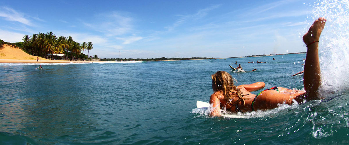
Arugam Bay, known locally as "Arugam Kudah", is a bay situated on the Indian Ocean in the dry zone of Sri Lanka's southeast coast, and a historic settlement of the ancient Batticaloa Territory (Mattakallappu Desam). The bay is located 117 kilometres (73 mi) south of Batticaloa, 320 kilometres (200 mi) due east of Colombo, and approximately 4 kilometres (2.5 mi) south of the market town of Pottuvil. The main settlement in the area, known locally as Ullae, is predominantly Muslim, however there is a significant Sri Lankan Tamil and Sinhala population to the south of the village, as well as a number of international migrants, largely from Europe and Australia. While traditionally fishing has dominated the local economy, tourism has grown rapidly in the area in recent years. Arugam Kudah's literal Tamil translation is "Bay of Cynodon dactylon". Tourism in Arugam Bay is dominated by surf tourism, thanks to several quality breaks in the area, however tourists are also attracted by the local beaches, lagoons, historic temples and the nearby Kumana National Park.
Adam's Peak

Adam's is a 2,243 m (7,359 ft) tall conical mountain located in central Sri Lanka. It is well known for the Sri Pada, i.e., "sacred footprint", a 1.8 m (5 ft 11 in) rock formation near the summit, which in Buddhist tradition is held to be the footprint of the Buddha, in Hindu tradition that of Shiva and in Islamic and Christian tradition that of Adam, or that of St. Thomas.
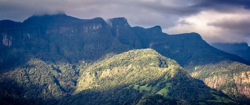
The mountain is located in the southern reaches of the Central Highlands in the Ratnapura District and Nuwara Eliya district of the Sabaragamuwa Province and Central Province —lying about 40 km northeast of the city of Ratnapura and 32 km southwest of the city of Hatton. The surrounding region is largely forested hills, with no mountain of comparable size nearby. The region along the mountain is a wildlife reserve, housing many species varying from elephants to leopards, and including many endemic species.
Adam's Peak is important as a watershed. The districts to the south and the east of Adam's Peak yield precious stones-emeralds, rubies and sapphires, for which the island has been famous, and which earned for its ancient name of Ratnadvipa.
Batticaloa
Batticaloa is a major city in the Eastern Province, Sri Lanka, and its former capital. It is the administrative capital of the Batticaloa District. The city is the seat of the Eastern University of Sri Lanka and is a major commercial city. It is on the east coast, 69 miles (111 km) south of Trincomalee, and is situated on an island. Pasikudah is popular tourist destinations situated 35 km northwest with beaches and flat year-round warm-water shallow-lagoons.
Batticaloa is in the eastern coast of Sri Lanka on a flat coastal plain boarded by the Indian Ocean in the east occupies a central part of the eastern Sri Lanka. Its average elevation is around 5 meters.[8] Batticaloa district has three lagoons such as Batticaloa Lagoon, Valaichchenai Lagoon, and Vakari (Panichchankerni) Lagoon. Among these lagoon, Batticaloa Lagoon is the largest lagoon and has 56 km long 162 square km area, extending from Pankudaweli in North and Kalmunai in South.
There are several islands within the Batticaloa Lagoon such as Puliayantheevu, Buffaloa Island and Bone Island. Many bridges are built across the lagoon connecting the landmasses and the islands. The Puliayantheevu is the metropolitan place of the city. The biggest bridge of all is Lady Manning bridge located at Kallady, which is the main access path to the city from the southern places of the district. This bridge is also famous for Singing fishes which were considered as musical sounds heard in the Kallady lagoon on a full moon day. A priest named Father Lang recorded this musical charm and broadcast it in the 1960s over the (Sri Lanka Broadcasting Cooperation)
Batticaloa beaches are sandy and located along 4 km shoreline in the city and further extend through the neighboring places. They include Kallady beach, Pasikudah and Kalkudah. Pasikudah is a bay protected from the ocean, with a flat and sandy bed extending 150 to 200 meters from the shore.
Bentota
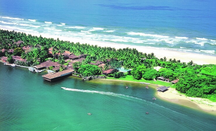
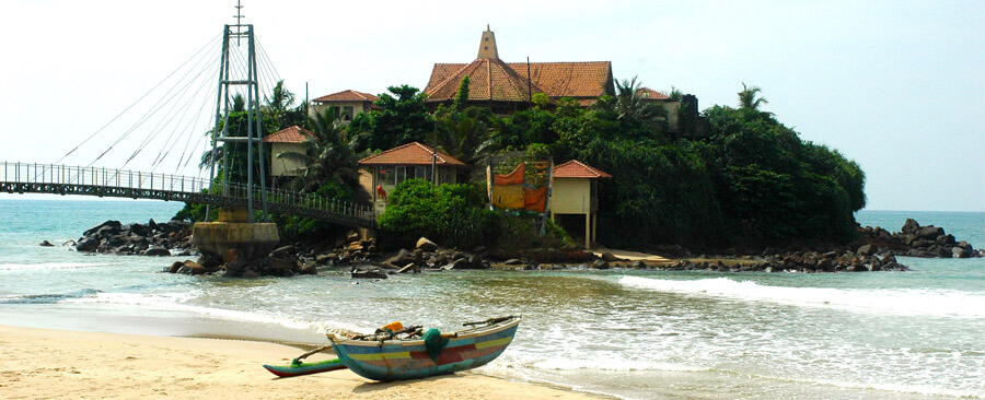
Bentota is a coastal town in Sri Lanka, located in the Galle District of the Southern Province, governed by an Urban Council. It is approximately 65 kilometres (40 mi) south of Colombo and 56 kilometres (35 mi) north of Galle. Bentota is situated on the southern bank of the Bentota River mouth, at an elevation of 3 metres (9.8 ft) above the sea level. The name of the town is derived from a mythical story which claims a demon named 'Bem' ruled the tota or river bank.
Bentota is a tourist attraction, with a local airport (Bentota River Airport) and a handful of world-class hotels. It is a destination for watersports. Bentota also delivers an ancient art of healing called Ayurveda. Bentota is famous for its toddy production, an alcoholic beverage made out of coconut nectar. It also has a turtle hatchery, located on Induruwa beach.
Beruwela
Beruwala is a town in Kalutara District, Western Province, Sri Lanka, governed by an Urban Council. The name Beruwala is derived from the Sinhalese word for the place where the sail is lowered. It marks the spot for the first Muslim settlement on the island, established by the Somali Shaykh Yusuf bin Ahmad al-Kawneyn, who converted the people into Islam. The town was originally named Berbereen (Now Beruwala) in honour and respect of the Shaykh.
A large population of Sri Lankan Moors, many of them gem merchants, still live in the town—particularly in the "China Fort and Maradana". "Masjid-ul-ABRAR" Maradana,(ESTD-920) a landmark of Beruwala and Sri Lanka's oldest mosque, was built by Somali traders on a rocky peninsula overlooking the town.
Beruwala is the starting point of the 130 kilometres (81 miles) long stretch of beach. In the past few years great strides have been made in the field of resort development in this area. The bay around remains ideal for bathing almost for the whole year.
Bundala National Park
Bundala National Park is an internationally important wintering ground for migratory water birds in Sri Lanka. Bundala harbors 197 species of birds, the highlight being the greater flamingo, which migrate in large flocks. Bundala was designated a wildlife sanctuary in 1969 and redesignated to a national park on 4 January 1993. In 1991 Bundala became the first wetland to be declared as a Ramsar site in Sri Lanka. In 2005 the national park was designated as a biosphere reserve by UNESCO, the fourth biosphere reserve in Sri Lanka.The national park is situated 245 kilometres (152 mi) southeast of Colombo.
The area was declared a wildlife sanctuary on 5 December 1969, and was upgraded to a national park on 4 January 1993 with land area of 6,216 hectares (24.00 sq mi).However the park was regazetted in 2004 and the original park was reduced to 3,698 hectares (14.28 sq mi). In 1991, Bundala became the first site in Sri Lanka to be designated a Ramsar wetland. In 2005, Bundala was declared a Man and Biosphere Reserve by UNESCO. In January 2006, an area adjacent to Bundala covering an area of 3,339.38 hectares (12.8934 sq mi) was declared as the Wilmanna Sanctuary.
Colombo
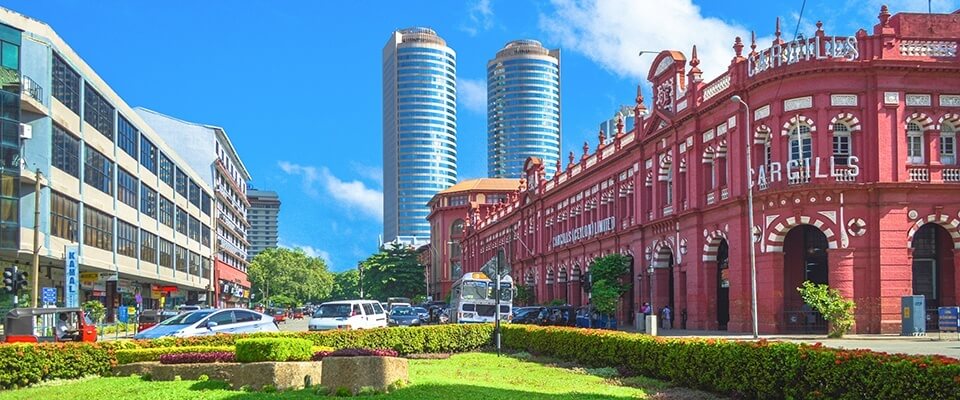
Colombo is the commercial capital and largest city of Sri Lanka. According to the Brookings Institution, Colombo metropolitan area has a population of 5.6 million. It is the financial centre of the island and a popular tourist destination. It is located on the west coast of the island and adjacent to the Greater Colombo area which includes Sri Jayawardenepura Kotte, the legislative capital of Sri Lanka and Dehiwala-Mount Lavinia. Colombo is often referred to as the capital since Sri Jayawardenepura Kotte is within the urban area of, and a suburb of, Colombo. It is also the administrative capital of Western Province, Sri Lanka and the district capital of Colombo District. Colombo is a busy and vibrant place with a mixture of modern life and colonial buildings and ruins. It was the legislative capital of Sri Lanka until 1982.
Due to its large harbour and its strategic position along the East-West sea trade routes, Colombo was known to ancient traders 2,000 years ago. It was made the capital of the island when Sri Lanka was ceded to the British Empire in 1815, and its status as capital was retained when the nation became independent in 1948. In 1978, when administrative functions were moved to Sri Jayawardenepura Kotte, Colombo was designated as the commercial capital of Sri Lanka.
Like many cities, Colombo's urban area extends well beyond the boundaries of a single local authority, encompassing other municipal and urban councils such as Sri Jayawardenepura Kotte Municipal Council, Dehiwala Mount Lavinia Municipal Council, Kolonnawa Urban Council, Kaduwela Municipal Council and Kotikawatte Mulleriyawa Pradeshiya Sabha. The main city is home to a majority of Sri Lanka's corporate offices, restaurants and entertainment venues. Famous landmarks in Colombo include Galle Face Green, Viharamahadevi Park, Beira Lake, Colombo Racecourse, Planetarium, University of Colombo, Mount Lavinia beach, Nelum Pokuna Theatre, Colombo Lotus Tower (under construction) as well as the National Museum.
Dambulla
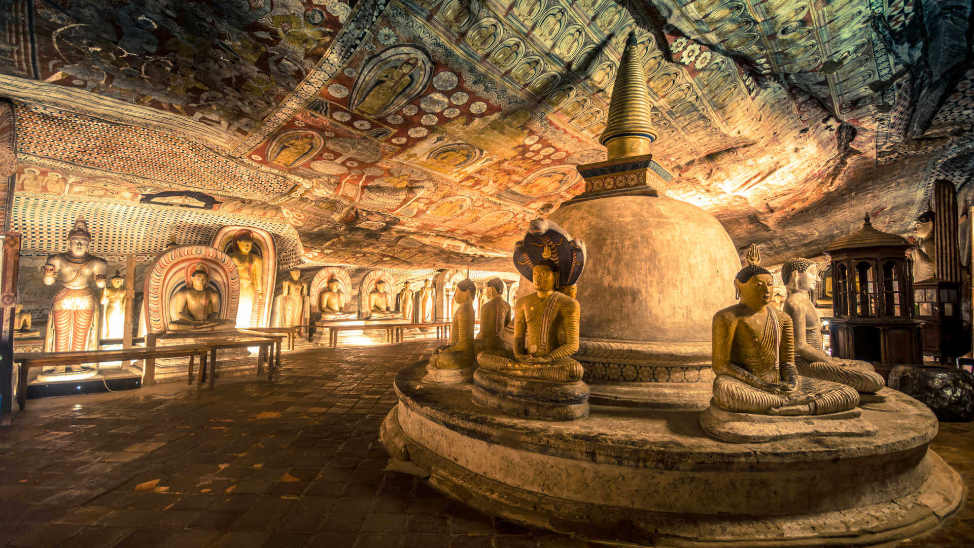
Dambulla is a large town, situated in the Matale District, Central Province of Sri Lanka, situated 148 km (92 mi) north-east of Colombo and 72 km (45 mi) north of Kandy. Due to its location at a major junction, it's the centre of vegetable distribution in the country.
Major attractions of the area include the largest and best preserved cave temple complex of Sri Lanka, and the Rangiri Dambulla International Stadium, famous for being built in just 167 days. The area also boasts the largest rose quartz mountain range in South Asia, and the Iron wood forest, or Na Uyana Aranya.
Ibbankatuwa prehistoric burial site near Dambulla cave temple complexes is the latest archaeological site of significant historical importance found in Dambulla, which is located within 3 km (1.9 mi) of the cave temples providing evidence of the presence of indigenous civilisations long before the arrival of Indian influence on the Island nation.
Ella

Ella is a small town in the Badulla District of Uva Province, Sri Lanka governed by an Urban Council. It is approximately 200 kilometres (120 mi) east of Colombo and is situated at an elevation of 1,041 metres (3,415 ft) above sea level.The area has a rich bio-diversity, dense with numerous varieties of flora and fauna. Ella is surrounded by hills covered with cloud forests and tea plantations. The town has a cooler climate than surrounding lowlands, due to its elevation. The Ella Gap allows views across the southern plains of Sri Lanka.
Located on the Colombo-Badulla railway line, and the A16 highway (Beragala-Hali Ela) a part of the Colombo-Badulla road.
Dhowa temple, a 2,000-year-old rock temple, is located on the Badulla-Bandarawela Road. It contains a 12 metres (39 ft) unfinished Buddha statue carved into the surrounding rock.
Galle

Galle is a city on the southwest coast of Sri Lanka. It’s known for Galle Fort, the fortified old city founded by Portuguese colonists in the 16th century. Stone sea walls, expanded by the Dutch, encircle car-free streets with architecture reflecting Portuguese, Dutch and British rule. Notable buildings include the 18th-century Dutch Reformed Church. Galle Lighthouse stands on the fort’s southeast tip.The Galle fort is a world heritage site and is the largest remaining fortress in Asia built by European occupiers.
Other prominent landmarks in Galle include the city's natural harbor, the National Maritime Museum, St. Mary's Cathedral founded by Jesuit priests, one of the main Shiva temples on the island, and Amangalla, the historic luxury hotel. On 26 December 2004, the city was devastated by the massive tsunami caused by the 2004 Indian Ocean earthquake, which occurred off the coast of Indonesia a thousand miles away. Thousands were killed in the city alone. Galle is home to the Galle International Stadium, which is considered to be one of the most picturesque cricket grounds in the world.The ground, which was severely damaged by the tsunami, was rebuilt and test matches resumed there on 18 December 2007.
Important natural geographical features in Galle include Rumassala in Unawatuna, a large mound-like hill that forms the eastern protective barrier to Galle Harbour. Local tradition associates this hill with some events of Ramayana, one of the great Hindu epics. The major river in the area is the Gin River (Gin Ganga), which begins from Gongala Kanda, passes villages such as Neluwa, Nagoda, Baddegama, Thelikada and Wakwella, and reaches the sea at Ginthota. The river is bridged at Wakwella by the Wakwella Bridge.
Hikkaduwa

Hikkaduwa is a seaside resort town in southwestern Sri Lanka. It’s known for its strong surf and beaches, including palm-dotted Hikkaduwa Beach, lined with restaurants and bars. The shallow waters opposite Hikkaduwa Beach shelter the Hikkaduwa National Park, which is a coral sanctuary and home to marine turtles and exotic fish. Inland, Gangarama Maha Vihara is a Buddhist temple decorated with hand-painted murals.
Hikkaduwa beach - reputed as the second best surfing spot in Sri Lanka.
Hikkaduwa Coral Sanctuary - located a few hundred metres offshore. The sanctuary has approximately seventy varieties of multi-coloured corals.
Horton Plains

Horton Plains National Park is a protected area in the central highlands of Sri Lanka and is covered by montane grassland and cloud forest. This plateau at an altitude of 2,100–2,300 metres (6,900–7,500 ft) is rich in biodiversity and many species found here are endemic to the region. This region was designated a national park in 1988. It is also a popular tourist destination and is situated 8 kilometres (5.0 mi) from Ohiya, 6 kilometres (3.7 mi) from the world famous Ohiya Gap/Dondra Watch and 32 kilometres (20 mi) from Nuwara Eliya.
The Horton Plains are the headwaters of three major Sri Lankan rivers, the Mahaweli, Kelani, and Walawe. In Sinhala the plains are known as Maha Eliya Plains. Stone tools dating back to Balangoda culture have been found here. The plains' vegetation is grasslands interspersed with montane forest and includes many endemic woody plants. Large herds of Sri Lankan sambar deer feature as typical mammals and the park is also an Important Bird Area with many species not only endemic to Sri Lanka but restricted to the Horton Plains. Forest dieback is one of the major threats to the park and some studies suggest that it is caused by a natural phenomenon.
Horton Plains is located on the southern plateau of the central highlands of Sri Lanka.The peaks of Kirigalpoththa (2,389 metres (7,838 ft)) and Thotupola Kanda (2,357 metres (7,733 ft)), the second and the third highest of Sri Lanka, are situated to the west and north respectively. The park's elevation ranges from 1,200–2,300 metres (3,900–7,500 ft).The rocks found in the park belong to the Archaean age and belong to the high series of the Precambrian era and are made up of Khondalites, Charnockites and granitic gneisses.The soil type is of the red-yellow podsolic group and the surface layer is covered with decayed organic matter
Jaffna
Jaffna is the capital city of the Northern Province of Sri Lanka. It is the administrative headquarters of the Jaffna district located on a peninsula of the same name. With a population of 88,138, Jaffna is Sri Lanka's 12th largest city.Jaffna is approximately six miles (9.7 kilometres) from Kandarodai which served as an emporium in the Jaffna peninsula from classical antiquity. Jaffna's suburb Nallur served as the capital of the four-century-long medieval Jaffna kingdom. Prior to the Sri Lankan civil war, it was Sri Lanka's second most populated city after the commercial capital Colombo. The 1980s insurgent uprising led to extensive damage, expulsion of part of the population, and military occupation. Since the end of civil war in 2009, refugees and internally displaced people have started to return to their homes and government and private sector reconstruction has begun.
Historically, Jaffna has been a contested city. It was made into a colonial port town during the Portuguese occupation of the Jaffna peninsula in 1619 who lost it to the Dutch, only to lose it to the British in 1796. And during the post-Independence civil war the rebel Liberation Tigers of Tamil Eelam (LTTE) occupied Jaffna in 1986. The Indian Peace Keeping Force (IPKF) briefly occupied the city in 1987. The LTTE again occupied the city from 1989 until 1995, when the Sri Lankan military regained control.
The majority of the city’s population are Sri Lankan Tamils with a significant number of Sri Lankan Moors, Indian Tamils and other ethnic groups present in the city prior to the civil war. Most Sri Lankan Tamils are Hindus followed by Christians, Muslims and a small Buddhist minority. The city is home to number of educational institutions established during the colonial and post-colonial period. It also has number of commercial institutions, minor industrial units, banks, hotels and other government institutions. It is home to many historical sites such as the popular Jaffna library that was burnt down and rebuilt and the Jaffna fort rebuilt during the Dutch colonial period.
Kalkuda & Passekudah

Kalkuda beach is located 282km east of Colombo in the eastern coast of Sri Lanka. Pasikudah beach is located just south of Kalkuda beach. The Eastern coast extending from Yala National Park (South East) spreads right up to the beautiful beaches of Nilaveli and Uppuveli at Trincomalee in the North-eastern coast.
Pasikudah Bay contains a shallow coral reef towards the outer bay with scattered groups of corals within the bay, and is connected to similar reef systems further south towards Kalkudah. It is one of the best-known reef systems in the east and has been proposed as a Marine Sanctuary by NARA. Pasikudah is very popular among visitors due to the calm clear waters which are ideal for swimming.
Pasikudah and Kalkudah beaches adorned with coconut palms set up an ideal stretch for bathing, Windsurfing and water skiing. Kalkudah Bay is a 2km long wide stretch of beach well protected by the off shore reef. Passekuda beach is wide and long. It spread along for 4km long just south of Kalkudah. The beach also houses a varied number of tropical fishes and exotic coral reefs. The combined beaches of Kalkudah and Pasikudah are ideal for bathing as the sea is clear, calm and reef-protected: perfect setting for sun bathing, windsurfing, and skiing.
Kandy

Historical records suggest that Kandy was first established by the King Wickramabahu (1357-1374 CE) near the Watapuluwa area, north of the present city, and it was named Senkadagalapura at the time, although some scholars suggest the name ‘Katubulu Nuwara’ may also have been used. The origin of the more popular name for the city, Senkadagala, could have been from a number of sources. These include naming it after a brahmin named Senkanda who lived in a cave near the city, after a queen of King Wickramabahu named Senkanda or after a coloured stone named Senkadagala.
In 1592 Kandy became the capital city of the last remaining independent kingdom in Sri Lanka after the coastal regions had been conquered by the Portuguese. Invasions by the Portuguese and the Dutch (16th, 17th and 18th century) and also by the British (most notably in 1803) were repelled. The last ruling dynasty of Kandy was the ‘Nayaks’ of Kandy while the Kingdom preserved its independence until it finally fell to the British in 1815. The British deposed the king, Sri Wikrama Rajasingha, and all claimants to the throne, thus ending the last traditional monarchy of Sri Lanka, and replacing it with their monarchy. As the capital, Kandy had become home to the relic of the tooth of the Buddha which symbolises a 4th-century tradition that used to be linked to royalty since the protector of the relic was seen fit to rule the land.
Thus, the Royal Palace and the Temple of the Tooth were associated with the administrative and religious functions of the capital city.
Even after its conquest by the British, Kandy has preserved its function as the religious capital of the Sinhalese and a place of pilgrimage for Buddhists, namely those belonging to the Theravada school.
Portuguese invasions in the 16th century and 17th century were entirely unsuccessful. The kingdom tolerated a Dutch presence on the coast until 1761, when King Kirti Sri attacked and overran most of the coast, leaving only the heavily fortified Negombo intact. When a Dutch retaliatory force returned to the island in 1763, Sri abandoned the coastline and withdrew into the interior of the island. When the Dutch continued to the jungles the next year, they were constantly harassed by disease, heat, lack of provisions, while the Kandyan sharpshooters, who hid in the jungle, inflicted heavy losses on the Dutch. The Dutch launched a better adapted force in January of 1765, replacing their troops’ bayonets with machetes and using more practical uniforms and tactics suited to speedy movement. They were initially successful, capturing the capital, but they took a deserted city, and the Kandyans withdrew to the jungles once more, refusing to engage in open battle. The Dutch, worn down by constant attrition, came to terms in 1766.
Sri Dalada Maligawa
The Sri Dalada Maligawa or the Temple of the Sacred Tooth Relic is a temple in the city of Kandy in Sri Lanka. It was built within the royal palace complex which houses the only surviving relic of Buddha, a tooth, which is venerated by Buddhists. The relic has played an important role in the local politics since ancient times and it’s believed that whoever holds the relic holds the governance of the country, which caused the ancient kings to protect it with great effort. Kandy was the capital of the Sinhalese Kings from 1592 to 1815, fortified by the terrain of the mountains which was difficult to approach. The city is a world heritage site declared by UNESCO, partly due to the temple.
Monks of the two chapters of Malwatte and Asgiriya conduct daily ritual worship in the inner chamber of the temple, in annual rotation. They conduct these services three times a day: at dawn, at noon and in the evening. On Wednesdays there is a symbolic bathing (Nanumura Mangallaya) of the Sacred Relic with a herbal preparation made from scented water and fragrant flowers.
This holy water is believed to contain healing powers and is distributed among devotees who are present.
The Esala Perahera in Kandy is one of the oldest and grandest of all Buddhist festivals, featuring dancers, jugglers, musicians, fire-breathers, throngs of devotees and lavishly decorated elephants This is in Esala (July or August), which is a month that is believed to commemorate the first teaching by Buddha after he attained enlightenment. The Kandy Esala Perahera lasts for ten days while the Sinhalese term ‘perahera’ means a parade of musicians, dancers, singers, acrobats and various other performers accompanied by a large number of caparisoned Tuskers and other elephants parading the streets in celebration of a religious event.
Kandy Lake
A lovely centrepiece to the town. Kandy Lake was created in 1807 by Sri Wickrama Rajasinha, the last ruler of the kingdom of Kandy. Several small-scale local chiefs, who protested because their people objected to labouring on the project, were put to death at stakes in the lake bed. The island in the centre was used as Sri Wickrama Rajsinha's personal harem, to which he crossed on a barge. Later the Birtish used it as an ammunition store and added the fortress style parapet around the perimeter of the lake. On the south shore, in fornt of the Malwatte Vihara, there's a circular enclosure which is the monk's bathouse.
Kandy Museum
The latest institution added to the Dalada Shrine is the `Sri Dalada Museum'. Ever since the Tooth Relic shrine was established in Kandy, different grades of visitors and devotees, ranging from the Roylty and Heads of States to the poorest of the general public, have been offering various gifts to the Sacred Tooth Relic, and these were preciously protected in specially built store-rooms by the successive line of Diyawadana Nilames. THE DALADA MUSEUM is located on the first and the second floors of the new wing called the Alut Maligawa set up by one of the past Diyawadana Nilemes, T.B.Nugawela. The display on the first floor consists of historical records from the time when the Tooth Relic was brought to Sri Lanka to the time of the British rule.
Peradeniya Gardens
Peradeniya Gardens Situated in the Hill capital Kandy. Visit to this garden will provide spectacles at extraordinary beauty and absorbing interest for any nature lover and casual visitor. 68 miles off-Colombo, 4 miles off Kandy this garden dates from 14th century reign of king Vikrama Bahu III. Peradeniya is well know for it's large variety of plants ornaments, useful machine and other creepers that produce the special spices at Sri Lanka. The great lawns highlight huge tropical trees and variety at bamboo can be found in one place.The best know attraction of the garden is the orchid House, which houses more than 300 varieties of exquisite orchids. A spice garden gives you a first hand introduction to the trees and plants used for the traditional Ayurvedic medicine.
Knukles
Its name describes its outline. The Knuckles Range consists of the Knuckles massif, the Knuckles range and the Knuckles peaks. The Knuckles massif is about 90 square miles in extent and is a detached block of the central highlands separated from the main highlands by the the Dumbara Valley. There are 35 peaks rising to more than 3000 feet (915 m) in the Knuckles range. It has a rich variety of plant and animal life. Mammals include leopards, sambhur, mouse deer, barking deer, sloth deer, leaf monkeys, toque monkeys, wild squirrels, giant squirrels, wild boar, otter and lorries. Besides these, many species of amphibians, reptiles, butterflies, spiders, fish and birds can be found here.
Kithulgala

Kitulgala is lovely little town on the banks of Kelani River, particularly famous for White Water Rafting. The town derives its name from strangely prehistoric-looking kitul tree, which abounds the region in vast numbers. Many of the resorts here have colonial aire and originally built for visiting colonial masters. Kitulgala is a nice place for those people who want to take a break in the lap of the mountains.
Adventure Sports
Adventure lovers often visit Kitulgala to enjoy the game of whitewater rafting which is arguably the best in Sri Lanka. Several movies have also been shot in the place, most famous of which is David Lean's award winning classic ‘Bridge on the River Kwai.' Movie lovers can visit the place to enjoy the original location where the movie was shot. Kitulgala sits prettily among the low waving hills carpeted by lush vegetation.
Kitulgala Village
The river flowing through the village is exceptionably enjoyable. Though generally broad, at Kitulgala, the Kelani River is shallow for the major part of its width and provides safe locations to swim and enjoy the waters and surroundings especially during the first three months of the year. The other bank can be accessed from the village by wading out in the shallow waters and then by a traditional outrigger canoe. The name of Kitulgala is derived from the Kitul Palm Tree (Sinhala: Sago Palm tree) that is found in abundance in the village of Kitulgala. Kitul palm syrup is a necessary ingredient in preparation of various traditional Sinhalese sweets.
White Water Rafting at Kitulgala
The stretch of the Kelani River, 5km upstream from the village of Kitulgala provides seven grade two and three rapids suitable for white water rafting. The upper section is suited for the experienced white water rafting adventurers while the lower section is suited for the beginners of white water rafting. In between the rapids are a few calm stretches of 6.5 km. The Kitulgala run takes about 90 minutes to complete. Each rapid brings off its own distinctive character. Their colourful names which include Head Chopper, Virgin’s Breast, Butter Crunch, Killer Fall and the Rib Cage could perhaps carry indications as what you can expect.
Birdlife at Kitulgala
Just across the Kelani River is a primeval forest with lush tropical flora, while it is home to about 54 rare species of birds. Though in a lesser density, most of the rain forest bird species that are found at the Sinharaja rainforest can be sighted at Kitulgala. Elusive endemic species like Sri Lanka Spurfowl, Green-billed Coucal and Spot-winged Thrush too are seen in the woods. The hills above the rubber plantations are populated with Mountain Hawk Eagles, Crested Treeswifts and Layard’s Parakeets.
Knuckles Range
The Knuckles Mountain Range also called Dumbara mountain range covers parts of Kandy and Matale districts and is separated from the Central Hills by the Mahaveli Valley to the South and East and the Matale Valley to the West. Its name derived from its shape of a clenched fist, which forms a scenic wonderland. What makes the Knuckles Forest/Mountain Range unique is the geographical character of its location. Perpendicular to the mountain range that runs from Laggala to Urugala runs three distinct but lesser ranges while there are other minor ranges running parallel to it. There are a total of 34 clearly identified such ranges with in the 62 square miles that makes up 3000-6500feet in height.
Knuckles range is home to mammals such as wild boar, spotted deer, giant squirrel, barking deer, purple faced leaf monkey, mongoose and porcupine are found here.
Among the endemic lizard species found at Knuckles range are Crestless Lizard (Calotes Leocephalus), Pigmy Lizard (Cophotis ceylonica) and Kangaroo Lizard (Otocryptus Wiegmanni) and are leaf nose lizard (Ceretophora Tennennti) is only found in this forest. Knuckles range is home to no less than 200 bird species. Fifteen of these species are endemic to Sri Lanka: Spot Wing thrush, Sri Lankan blue magpie Jungle fowl, Yellow-fronted barbet, small barbet, Sri Lankan warbler, White faced starling, Sri Lanka white-eye, Black headed bulbul, Yellow eared bulbul, dusk blue flycatcher, brown capped babbler and Layard’s parakeet.
Weather and Season
Weather in the Knuckles mountain range is unpredictable and could transform within few minutes. A thick mist could shroud the mountains in a mater of minutes. Rain could breeze in any day.
December to February is a good period to enjoy trekking at Knuckles. Possibility of rain is moderate. March to May too is a good period to go trekking in Knuckles with the possibility of rain being low. June to September being the period with the lowest possibility of rain, it presents the best oppotnity. September to November is the period that doesn’t attract the trekkers in view of high
Climate at Knuckles Range
The average rainfall at Knuckles range lies between 3000-5000ml while the temperature ranges between 5.5 degrees and 35 degrees Celsius. The Southwest Monsoon brings rain through a gap in the range of mountains. The average wind speed has been measured to be approximately 7.2km/hour and humidity in the range lies between 57%-90%.
Knuckles mountain range is inhabited by traditional villagers who live in 37 ancient villages. The existence of theses indigenous community depends upon rice cultivation, Chena cultivation and Cardamom cultivation. The transportation of the produce is done by means of Pack Ox called Thawalama. Meemure has been such a traditional village of Sri Lanka, it was only in the year 2008 that the electricity arrived therein.
Biodiversity at Knuckles Range
Knuckles range is home to mammals such as wild boar, spotted deer, giant squirrel, barking deer, purple faced leaf monkey, mongoose and porcupine are found here.
Among the endemic lizard species found at Knuckles range are Crestless Lizard (Calotes Leocephalus), Pigmy Lizard (Cophotis ceylonica) and Kangaroo Lizard (Otocryptus Wiegmanni) and are leaf nose lizard (Ceretophora Tennennti) is only found in this forest. Knuckles range is home to no less than 200 bird species. Fifteen of these species are endemic to Sri Lanka: Spot Wing thrush, Sri Lankan blue magpie Jungle fowl, Yellow-fronted barbet, small barbet, Sri Lankan warbler, White faced starling, Sri Lanka white-eye, Black headed bulbul, Yellow eared bulbul, dusk blue flycatcher, brown capped babbler and Layard’s parakeet.
Mannar

Mannar district is located in the north west of Sri Lanka in the Northern Province. It has an area of 1,996 square kilometres . Aruvi Aru is the second longest river in Sri Lanka and runs through Mannar and Anuradhapura districts. Mannar has artesian springs and aquifers. These water supply comes from Sri Lanka's central areas. The Northern Province has a supply of fresh water from aquifers and it was used in successful cultivation. It only exists in the areas where Red Yellow Latosol exists. These types of aquifers do not exist where Reddish Brown Earth is found. The rest of the Vanni area is void of perennial supply of fresh water.
Adam’s bridge
In the west flank of the peninsular, close to Thalaimanar, lies a string of peculiar sand mounds that link in a chain to Danuskoti, India. According to legend, this where, in the famous epic Ramayana, the king Rama marched his army to free Sita from bandit Rawana. Piercing the vast Indian Ocean like pointed dagger, it is phenomenal natural creation. The strip is home numerous sea urchins, water birds and people alike. It’s a place to unwind and capture the splendour of mother-nature.
The Giants Tank
Sri Lanka’s most ancient tank (lake), that is not mentioned in the chronicles. The shear length of the embankment is five miles alone. It was built before the 12th century and is a stunning point to witness the sun-set and bird life. The tank precincts have now a declared a sanctuary.
Tirikosweram Temple
There has been an ancient landing point connected to the pearl fishery of Marrichkuddi near the great temple, according to historical details. The sprawling temple complex is highly venerated (Isuram’s of Siva) by the Hindus as well as other faiths. The gigantic veil cart’s (elaborately decorated wooden carriages that parade the streets during the festive times) are a great feature here.
The Doric and the port of Arrippu
A curios building perched on the beach cliff is the residence of Governor Lord Gulidford built to inspect the flourishing pearl fishery of Marrichkudi. The “Doric” stands for its unique architecture. The shell littered beach bears testimony to the quest of pearls where man and beast succumb in numbers. The Dutch had a fort here and the conditions were so inhospitable that they finally had to abandon it. The fugitive Robert Knox set sail to India from here after 19 years of captivity in the Kingdom of Kandy. Today the pearls are exhausted and what remains is the cries and the echoes of gallant men who tried their fortune in a savagely beautiful land.
Mannar Island Lighthouses
Situated at the end of Talaimannar Road is the Talaimannar pier. The ancient light house there is a construction done by the British in 1915. It is a white concrete round cylindrical tower with a height of 17 metres. Every five second, a light which has the luminous range of 10 NM flashes as a beacon to vessels out at sea. The lighthouse is not used at present even though it is in working condition.
Mahiyangana & Dambana

Mahiyangana Stupa
Mahiyangana Stupa is the most prominent cultural attraction in Mahiyangana. Mahiyangana region, a plain with Mahaweli river running through it provides access to a several National Parks, bird sanctuaries and aborigine lands: Sorabora Wewa reservoir, Dambana, Ulhitiya Wewa reservoir, Minipe reservoir, Randenigala reservoir, Maduruoya wildlife park, Wasgomuwa wildlife park are the major attractions.
The ancient Mahiyngana stupa is located 1km south of the city center. The gleaming great white stupa built in the shape of a bell, sits pretty atop a massive platform. The sculptures of elephant heads built onto the platform stand proudly as if to guard the stupa. A well laid out and well maintained long straight walkway stretches from the decorated Makara Thorana (Sinhala: dragon arch) to the stupa.The ancient Mahiyngana stupa is one of the sixteen most venerated Buddhist stupas of Sri Lanka. It is believed Buddha’s hair relic is enshrined within the ancient Mahiyangana.
Sri Lanka’s greatest historical chronicle, Mahawamsa reveals that nine moths since the supreme enlightenment of Buddha, having foreseen that the island of Sri Lanka is destined to have the Buddhism established and remain so for 5000 years, visited the island to preach the doctrine to the pre-historic inhabitants belonging to the tribes of Yaksha, Naga and deva. Prince Saman of Deva tribe, having attained the first spiritual plane of Buddhism called Sovan, begged Buddha for a token of presence that could be held high in reverence: he was granted a curl of hair off Buddha’s head. Prince Saman had the ancient Mahiyangana Stupa was built enshrining the hair relic, which was secured in a golden reliquary. Thus Mahiyangana became the first ever stupa to be built in Sri Lanka.
Matara & Tangalle
Matara (originally Mahathota) is a city on the southern coast of Sri Lanka, 160 km from Colombo. It is one of the largest cities in Sri Lanka. The history of Matara dates back to the Anuradhapura period. Matara is full of natural scenic beauty, which is an attraction to the tourists.The river Nilwala has fertilized the whole area where one can see the stretch of paddy fields and tea estates with plantation of spices also taking an important place. Matara was once called ‘Mahathota’ that translates into ‘Great Ferry’. Matara has been under the rule of many rulers. The Portuguese administered Matara from 1790 to 1795, while the British ruled it from 1796 to 1948. The Dutch were also dominant forces in Matara for some time.
Tangalle has spread since those days to absorb former satellite villages, so that it now comprises not just one bay but a series of them. Approaching Tangalle from the west, you will encounter Goyambokka and Pallikkudawa, situated on a double bay south of the town. Beyond the town and harbour is the large bay, are Medaketiya and Medilla. Medaketiya in particular has fine white sand, excellent swimming, and is rarely crowded. The most popular day excursion from Tangalle is to the stunning rock temple of Mulkirigala, 20km to the north where after ascending a series of rock steps you will reach few natural caves with numerous wall paintings and Buddha statues. One cave houses a library in which, a most important discovery was made in 1826 by a British administrator who found some long-unseen palm-leaf manuscripts containing the key to translating the Mahawamsa, the Great Chronicle of Sri Lanka. Mulkirgala is a strenuous climb in some places, reasonably easy in most. It is well worth making it the summit, for there are magnificent views to be had of the surrounding countryside.
Weligama and Mulgirigala Rock Temple.
Matara was once called ‘Mahathota’ that translates into ‘Great Ferry’. Matara has been under the rule of many rulers. The Portuguese administered Matara from 1790 to 1795, while the British ruled it from 1796 to 1948. The Dutch were also dominant forces in Matara for some time.
Veherahena Temple
Veherahena temple is famous in Matara for the 25 m high colorful Buddha statue. Veherahena temple is 2 km from the town centre.
Wevrukannala
Wevrukannala temple, situated near Dickwella, is known for a 150 ft high Buddha statue. It is the highest Buddha statue in Sri Lanka, which can be accessed from inside by tourists and ascended to enjoy the view from top. The temple also displays hundreds of brightly painted and gilded models depicting scenes from the life of Buddha.
Matara Beaches
Matara (originally Mahathota) is a city on the southern coast of Sri Lanka, 160 km from Colombo. It is one of the largest cities in Sri Lanka. The history of Matara dates back to the Anuradhapura period. Matara is full of natural scenic beauty, which is an attraction to the tourists.The river Nilwala has fertilized the whole area where one can see the stretch of paddy fields and tea estates with plantation of spices also taking an important place. Matara was once called ‘Mahathota’ that translates into ‘Great Ferry’. Matara has been under the rule of many rulers. The Portuguese administered Matara from 1790 to 1795, while the British ruled it from 1796 to 1948. The Dutch were also dominant forces in Matara for some time.
Negombo
NEGOMBO Negombo is located approximately 37 km north of commercial capital Colombo in Sri Lanka. It is located at the mouth of the Negombo lagoon. The major beach resort in the West Coast is Negombo. The wide sandy beaches and the safe sea are the major attractions of Negombo and it is perfectly located within the 7 km from the Bandaranaike International Airport in Sri Lanka. Negombo has a small port, and its economy is mainly based on tourism and its centuries-old fishing industry. Negombo is a traditional fishing town of Sri Lanka. Regarded as the traditional fishing town, no wonder Negombo is a gourmet's delight with seafood available in plenty. Also produces spices, ceramics and brassware.
Negombo has a majority of Roman Catholics along with Buddhists, Hindus and Muslims. Negombo has been given the name "Little Rome" due to the highly ornate Portuguese-era Roman Catholic churches found within the township.
The town has several buildings that date back to the Dutch and Portuguese colonial era. Attractions in the city are the old Dutch fort gate built in 1672 now a part of the prison, the Dutch Canal which was then a supply route to the Dutch administration, old churches and fishing villagers. The 100km long canal running through the town is still being used and is an attraction for those who want to see the country from a different perspective. The Katuwapitiya Church and the Grand Street Church are two biggest parishes in Negombo. "Agurukaramulla temple" is a famous Buddhist temple bringing Buddhists from all over Sri Lanka to Negombo every year.
The wide sandy beaches and the safe sea are the major tourist attractions of Negombo, use the town for the first or the last night of their stay in Sri Lanka. Negombo offers some of the better beaches on the west coast of Sri Lanka, and draws tourists who stop over for a day on their way to or from the airport. Several hotels ranging from luxury hotels to small hotels, guest houses and restaurants have in Negombo. Some quiet stretches of the beach are maintained by the tourist hotels. While others are always busy with fisherman and their equipment. Water-sports and diving are also extremely popular among visitors, with a few well preserved coral reefs and a 50 year old shipwreck that serves as an artificial reef for many varieties of fish. There are also local handicraft sales on the beaches and the shops near the town.
Negombo Lagoon
Negombo Lagoon is a large estuarine lagoon in Gampaha District, south-west Sri Lanka. The Negombo Lagoon has an area of 3164 hectares and is situated some 40 km north of Colombo. It is part of a much larger Muthurawajawela Marsh-Negombo Lagoon coastal wetland. The lagoon is fed by a number of small rivers and a canal. It is linked to the sea by a narrow channel to the north, near Negombo town. The lagoon is surrounded by a densely populated region containing rice paddies, coconut plantations and grassland. The land is used for fishing and agriculture.The lagoon has extensive mangrove swamps. The lagoon attracts a wide variety of water birds including cormorants, herons, egrets, gulls, terns and other shorebirds.
Dutch Fort in Negombo
One of the most distinct tourist attractions in Negombo is undeniably the Old Dutch Fort. A structure that harks back to Sri Lanka’s colonial days when the nation was once under the rule of the Portuguese and then the Dutch.The city was encircled by an earth wall. Eventually the landmass on which the Old Dutch Fort Gate, Negombo was constructed was regularly washed by the sea.
The coastal town of Negombo is an area in Sri Lanka that is dominated heavily by the Christian Faith and one of town’s most important structures is St. Mary’s Church. This holy building is lavish and grand in nature, standing tall amidst other structure in the town. The church consists of three main levels which are immediately apparent when approaching the structure from the front.
Trincomalee & Nilaveli
Trincomalee, one of the finest natural deep-water harbors in the world is located 257 km north-east of Colombo, capital city of Sri Lanka. Trincomalee is home to fine beaches of Nilaveli, Uppaveli and off-shore Pigeon Island. Recently Trincomalee has become popular as a Whale Watching destination too. The Dive centers at Nilaveli, Uppaveli support the tourists to enjoy their holidays in diving, snorkeling and swimming. Trincomalee district, called Gokanna or Gokarna in the historical chronicles and inscriptions, being studded with a multitude of ruins of ancient Buddhist temples, is a major Sinhalese Buddhist cultural and archeological site of Sri Lanka. The seven hot springs at Kanniyai located just 8km from Trincomalee attract regular crowds throughout the year in view of the therapeutic properties of water therein varying in temperature from one well to the other.
Trincomalee Harbor
Nuwara Eliya which is at an elevation of 1890 meters above the sea level is the highest city in Sri Lanka and it lies beneath the tallest peak of the island, Pidurutalagala or Mount Pedro (2555 meters).
Nilaveli Beach
The most popular attraction in Trincomalee. Situated about 10Km from the Trincomalee town it is one of the most beautiful white sand beaches in the world. If you manage to visit when the sea is calm you can see the clear blue water and it’s a breathtaking site. There are many hotels and resorts near the beach for you to enjoy some delicious sea food. If you manage to get up early you view a breathtaking sunrise. A must visit place in Trincomalee.
Marble Beach
calm as glass. Low depth and the calmness of water has made Marble beach one of the best beaches to swim in Sri Lanka. Marble beach is maintained by Sri Lana Army. There you can find everything you needed for a perfect vacation.
Nuwara Eliya

Nuwara Eliya is a city in the tea country hills of central Sri Lanka. The naturally landscaped Hakgala Botanical Gardens displays roses and tree ferns, and shelters monkeys and blue magpies. Nearby Seetha Amman Temple, a colorful Hindu shrine, is decorated with religious figures. Densely forested Galway's Land National Park is a sanctuary for endemic and migratory bird species, including bulbuls and flycatchers.
The Climate, Terrain and Vegetation of Nuwara Eliya
Nuwara Eliya which is at an elevation of 1890 meters above the sea level is the highest city in Sri Lanka and it lies beneath the tallest peak of the island, Pidurutalagala or Mount Pedro (2555 meters).
Spring in Nuwara Eliya
The salubrious climate has branded Nuwara Eliya into a sanatorium that attracts Sri Lankan tourists as well as foreign travellers to the seasonal event during February to April. Golf tournaments, horse racing, motor cross, clay pigeon shooting and carnival features are some of the main festivities. The downside of the season is the accommodation rates that shoot up above all. With thousands of local tourists flocking to Nuwara Eliya filling up hotels and guest houses that provide budget accommodation in the season and narrowing the accommodation options, foreign tourists would find it necessary to have the hotel bookings sorted out well in advance.
Victoria Park at Nuwara Eliya
In the centre of the town is the local Central Market. South of the market is Victoria Park spreading over an expanse of 27 acres with well maintained shrubs and trees. The cluster of exceedingly tall eucalyptuses is a main feature therein. Victoria Park though is located at close proximity to the city centre, is an ornithological hot spot where bird lovers would spend long hours. River Nanu Oya that runs through the Victoria Park and a number of lakes within it supports the endemic birds of Sri Lanka as well as migrant birds from neighbouring countries and regions such as the Himalayas. Among the birds are Kashmir flycatcher, Indian blue robin, Pied thrush, Dull-blue flycatcher and the yellow-eared bulbul.
Race Course and Golf Course at Nuwara Eliya
To the South of the Victoria Park is the Racecourse and behind the Race course is Lake Gregory. Nuwara Eliya’s finest Golf Course is located just opposite the Victoria Park. Built in 1891 by the British colonialists in Sri Lanka, then called Ceylon, this 18-hole golf course is well maintained by the Nuwara Eliya Golf Club. The club rents golf equipment and charges a fee for playing at its golf course.
Horton Plains
The Horton Plains National Park, A UNESCO World Heritage is perched on the edge of the Central Highlands midway between Nuwara Eliya and Haputale, another hill country retreat, which consists of the highest plateau of Sri Lanka at 2000 feet and a paradise of bird watchers, nature lovers and hikers. The precipice that falls vertically for over 1050 meters in the park at the southern edge of the highlands to the lowlands below, called World’s End, is an excursion that wouldn’t be missed at all by the holiday makers at Nuwara Eliya.
Pinnawala

Elephants are magnificent land animals, with a thick skin and a curved trunk. Watching these gigantic wild, semi wild mammals is a lifetime experience. Sri Lanka has considerable number of the world’s elephant population. Visitors can enjoy watching wild elephants in wildlife parks such as Yala, Wasgamuwa, Udawalawa, Habarana and Mineriya.
But to those who want to see the tamed and semi wiled elephants in close proximity the best place is the “Pinnawala Elephant Orphanage”.
It is located northwest of Kegalle town along the Colombo ~ Kandy main road. The orphanage is in a twenty five acre coconut land near Maha Oya. The wide area of shallow water and the huge rocks of Maha Oya make the ideal place to these magnificent animals.
This facility was established in year 1975 as a conservation breading center for Elephants by Sri Lanka Wildlife department. It was started with a heard of five baby Elephants. In year 1978 it was taken over by the National Zoological Gardens of Sri Lanka. Pinnawala Elephant orphanage is treated as one of the largest breading center in the world.
Prior to the invasion of the British in Sri Lanka in 1815, an estimated 30,000 elephants lived on the island. In the 1960s, following nearly a century of game hunting and jolly slaughter by the British colonialists, the elephant population was close to extinction. The tragedy of decimation of the elephant population prompted the Government of Sri Lanka to found Pinnawala (Pinnawela) Elephant Orphanage. Today, the number of elephants living in wilderness exceeds 3,000.
Polonnaruwa

Polonnaruwa was the second capital of Sri Lanka after the destruction of Anuradhapura in 993. It comprises, besides the Brahmanic monuments built by the Cholas, the monumental ruins of the fabulous garden-city created by Parakramabahu I in the 12th century.
Polonnaruwa bears witness to several civilizations, notably that of the conquering Cholas, disciples of Brahminism, and that of the Sinhalese sovereigns during the 12th and 13th centuries. This immense capital created by the megalomaniac sovereign, Parakramabahu I, in the 12th century, is one of history's most astonishing urban creations, both because of its unusual dimensions and because of the very special relationship of its buildings with the natural setting. It is also a shrine of Buddhism and of Sinhalese history. The tooth of the Lord Buddha, a remarkable relic placed in the Atadage under Vijabayahu, was considered as the talisman of the Sinhalese monarchy: its removal by Bhuvanaikabahu II confirmed the decline of Polonnaruwa.
After the destruction of Anuradhapura in 993 by Rajaraja, Polonnaruwa, a temporary royal residence during the 8th century, became the capital. The conquering Cholas constructed monuments to their religion (Brahmnism), and especially temples to Shiva where fine bronze statues, today in the Museum of Colombo, were found. The reconquest of Ceylon by Vijayabahu I did not put an end to the city's role as capital: it became covered, after 1070, with Buddhist sanctuaries, of which the Atadage (Temple of the Tooth Relic) is the most renowned.
The apogee of Polonnaruwa occurred in the 12th century AD. Two sovereigns then proceeded to endow it with monuments. Parakramabahu I (1153-86) created within a triple-walled enceinte a fabulous garden-city, where palaces and sanctuaries prolonged the enchantment of the countryside. The following monuments date from this reign: the Lankatilaka, an enormous brick structure which has preserved a colossal image of Buddha; the Gal Vihara, with its gigantic rock sculptures which may be placed among the chefs-d'œuvre of Sinhalese art; the Tivanka Pilimage, where wall paintings of the 13th century illustrate the jataka (narratives of the previous lives of Buddha), etc. Nissamkamalla hastily constructed monuments that, although less refined than those of Parakramabahu I, were nonetheless splendid: the Rankot Vihara, an enormous stupa 175 m in diameter and 55 m high, is one of the most impressive; its plan and its dimensions are reminiscent of the dagabas at Anuradhapura.
After this golden age, Polonnaruwa underwent a century of difficulties, before its final decline. The city which was invaded by the Tamils and the Maghas, then reconquered in a precarious manner, was only periodically the capital before the end of the 13th century when it was captured in an assault by Bhuvanaikabuha II, who set up his government at Kurunegala.
Ratnapura

Ratnapura meaning City Gems in Sinhalese, the main source of precious and semiprecious stones (including rubies, sapphires, and cat’s-eyes) mined in the valleys by River Kalu Ganga that flows through the district, is located 103 m from Colombo in the Sabaragamuwa district of wet Zone of Sri Lanka.
The high rainfall (4,000 to 5,000 mm annually) at Ratnapura district in a valley (21m above sea-level) by the River Kalu Ganga Ratnapura has resulted in rich vegetation, an environment of greenery interspersed with streams and waterfalls. Ratnapura affords grand views of the surrounding countryside, in particular the famous and revered mountain, Adam’s Peak (Sri Pada). The most visited waterfalls at Ratnapura are Bopath Ella Falls at the village of Kuruvita and Katugas Ella Falls at the village of Mahawelawatta and Kirindi Ella Falls.
Ratnapurais one of the most beautifully situated towns in Ceylon, except for its climate, which is aptly compared to a Turkish bath. Still it is this hot moist temperature which makes all leaf and blossom more luxuriant in Ratnapura than anywhere else.
Ratnapura district has produced an incredible variety of gemstones, many of them outstanding in comparison with stones from other regions. Sapphire occurs in all hues of blue, as well as yellow, violet, green, pink, and the remarkable pinkish-orange “padparadsha.” Other gemstones include topaz in bright yellow with a reddish tinge; brownish yellow to cinnamon-colored grossular; orange-yellow spessartine; blood-red pyrope; red to brownish red almandine; the world’s finest zircon in a broad spectrum including brown, yellow, orange, green, and colorless (known locally as ‘Matara diamond’—a misnomer); green, yellow, and brown tourmaline; yellow, green, and brown chrysoberyl; yellow chrysoberyl cat’s-eye; the unique white translucent variety of microcline with a blue sheen known as moonstone; and great quantities of spinel in brown, green, blue, purple, violet, yellow, pink, and red. Unusual and rare stones from the same area include sillimanite, andalusite, scapolite, enstatite, kornerupine and diopside.
Ratnapura Gemological Museum
The gemological Museum at Ratnapura houses an array of fabulous samples of precious and semi-precious gems: rubies; sapphires; amethyst. Among the other exhibits are the images, artefacts and tools that elaborate the history and the processes of the industry. The museum features a souvenir shop and a restaurant.
Ratnapura National Museum
Ratnapura National Museum is set up at the renovated building called “Ehelepola Walauva” once belonged to a minister Ehelepola of the last king of Sri Lanka. The beautiful building on Ratnapura - Colombo road was opened for the public as a museum in 1988. Among the exhibits are prehistoric archaeological inventions, geological, anthropological, zoological artifacts and models related to the Sabaragamuva Province. Portrayal of the folk life of the region including various forms of dress, ornamentation, weaponry, musical instruments is an important aspect of the museum.
Ratnapura Maha Saman Devale
Maha Saman Devale is a shrine dedicated to God Saman-the tutelary deity of Adam's Peak constructed on the site of the Portuguese church and fort after the area was recaptured by the Kandyan kingdom from the Portuguese. "The Maha Saman Devale, Ratnapura is very impressive—the grandest in size and setting of all the devales I have seen. Approached up long stone steps flanked by dug out boats on either side (ready for the annual goods) one senses at once that one is entering a place of myths and legends and offine style and historic Importance. Here a king at war must have been a king indeed and the palatial walauwas in the province seem a right and proper architectural support to the central place Of worship of its people. The devale compound is bound by a low, tiled and windowed, wall within which its space is ordered and emphasized by pavilion roofs, culminating in a three tiered tower at one point, with two other deeply eaved shrine roofs for balance on the vast flat quadrangle. The impression is of triangular weight airborne on carved pillars on a flat sandy expanse, glimpsed through ever changing frames as one walks through the cloisters."—Barbara Sansoni
Sigiriya
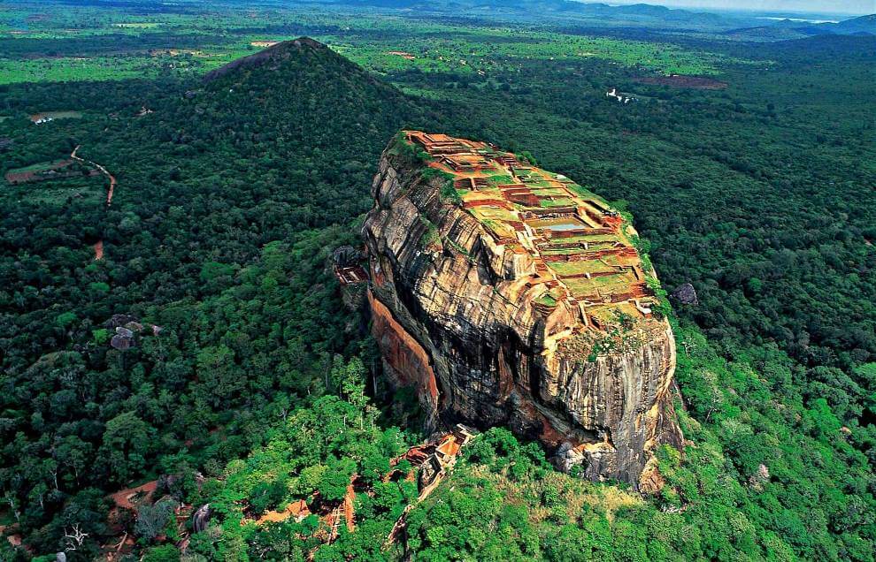
Often referred to as the 8th wonder of the world, the ancient rock fortress of Sigiriya is a marvel that baffles even modern-day architects. The astounding height at which the castle was built, the many nooks and crannies holding centuries-old cherished secrets, and the still functioning water fountains in the fortress’s extensive gardens all offer a world of wonder to all those who visit. A UNESCO World Heritage Site, Sigiriya is a place that a person must visit at least once in their lifetime.
A bit of history
King Kashyapa I, the king’s son by a non-royal concubine, built Sigiriya to be impenetrable. Kashyapa I seized the throne after entombing his father, King Dhatusena, within a wall while still alive; the true heir to the throne, Moggallana, fled to South India, as he feared for his life. It was out of fear of an attack that Kashyapa I moved the capital as well as his residence from Anuradhapura to Sigiriya and built his fortress and pleasure palace on top of a rock where no one could reach it.
After assembling an army in India, Moggallana returned to Sri Lanka and declared war against King Kashyapa I. However, during the battle, King Kashyapa I’s soldiers deserted him, and he, in turn, committed suicide by falling on his sword.
Before King Kashyapa I
Archaeologists believe that the site was first inhabited during prehistoric times. The rock, formed from the magma of an extinct volcano, provides different shelters, including caves, which hold evidence that it sheltered Buddhist monks and ascetics from as early as the 3rd century BCE.
Beware of the wasps
Before you begin your ascent up the rock, please beware that on some parts of the rock face there are many wasps’ nests, and they are quick to attack. Visitors must be extra careful and wear clothing that covers the body in case of an attack; it is also important to be extremely quiet on the way up so as not to provoke the wasps.
You enter through the Lion Gate
The entrance to the palace is flanked by massive stone paws of a lion, which inspired Sigiriya’s name, which means “Lion Rock.” The entry to the castle used to be through the mouth of a lion; however, over time, the head collapsed, leaving only the paws.
The beautiful frescoes have inspired many people
Perhaps the best-known feature of Sigiriya are the colorful murals, located in the “Cobra Hood Cave,” depicting beautiful damsels holding flowers. At one point, an area measuring 140 meters long (459 feet) and 40 meters high (131 feet) featured over 500 of these maidens; however, only a few remain today. The subject of much adoration, many poets who have visited Sigiriya over the centuries have penned their thoughts, and most of these can still be seen today on the Mirror Wall.
“Graffiti” covers the Mirror Wall
Researchers believe the Mirror Wall was originally highly polished so that the king could see himself as he walked by the wall. Today, however, it features the “graffiti” of visitors who have visited Sigiriya, some of which date back to the 8th century. These inscriptions, including poems, as translated by Dr. Senerat Paranavitana, describe the feelings of awe that visitors felt when witnessing the beauty and the grandeur of the castle.
The gardens are some of the oldest in the world
Sigiriya features a series of gardens – of the water, boulder, as terraced varieties – that remains one of the best examples of ancient urban planning. The water gardens consist of ponds, pools, and fountains that are still functional, especially during the rainy season. The boulder gardens comprise large boulders and winding paths, while the terraced gardens consist of a series of terraces, which rise from the pathways of the boulder garden up to the staircases on the rock.
The summit is home to ruins, gardens, and incredible views
The ancient citadel once sat at the top of the rock, and remnants of a glorious past are still visible today. The buildings’ foundations, spread over 1.5 hectares, remain intact, as do the terraces and gardens. The summit also features a large pool, made by cutting into the rock, as well as smaller pools made of brick. The view is breathtaking and is fully worth the climb.
Sinharaja Rain Forest
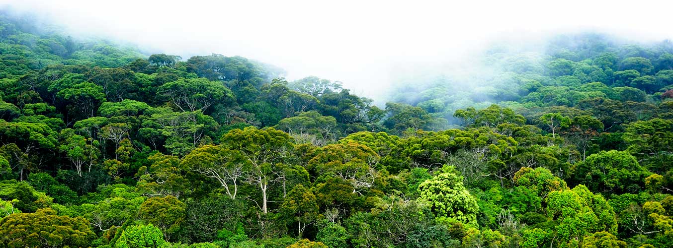
Location of Sinharaja Rain Forest in Sri Lanka
Sinharaja Rain Forest (a UNESCO World Heritage Site), the last viable remnant of Sri Lanka’s tropical lowland rainforest spanning an area of 18900 acres is located within Sabaragamuwa and Southern provinces of the south-west lowland wet zone of Sri Lanka. Sinharaja is bounded by rivers on three sides. On the north, Sinharaja is bounded by the Napola Dola and Koskulana Ganga. On the south and south-west are the rivers Maha Dola and Gin Ganga. On the west are the river Kalukandawa Ela and river Kudawa Ganga. To the east of Sinharaja is an ancient footpath near Beverley Tea Estate and by the Denuwa Kanda. 6°21′-6°26’N, 80°21′-80°34’E.
Reaching Sinharaja Rain Forest
From Northern or western parts of the country you can reach Sinharaja Forest Reserve via Ratnapura, Kiriella, Kalawana, Weddala. From the South you can enter Sinharaja Rain Forest from Deniya. Coming form Hambantota, Udawalawe you can enter Sinharaja from Rakwana side.
Area of Sinharaja Rain Forest
The total area of the Sinharaja Forest Reserve is 18,900 acres or 7,648 hectares. It ranges in altitude from 300m to 1,170m.
Significance of Sinharaja Forest
Sinharaja Forest reserve is also home to over 50% of Sri Lanka’s endemic species of mammals and butterflies, as well as many kinds of insects, reptiles and rare amphibians.
Establishment of Sinharaja Forest Reserve
Most of the area of Sinharaha forest was originally declared a forest reserve under the Waste Lands Ordinance in 1875. In 1978, Sinharaja Rain Forest was included in the international network of biosphere reserves, established and maintained as part of UNESCO’s Man and the Biosphere (MAB) program. In October 1988, this reserve, together with a northeastern extension of it, was declared Sri Lanka’s first National Wilderness Heritage Area. In December 1988, the Sinharaja Biosphere Reserve became Sri Lanka’s first natural site to be added to UNESCO World Heritage list.
Climate of Sinharaja Rain Forest
Meteorological records gathered from in and around Sinharaja over the last 60 years reveal the annual rainfall of Sinharaja Forest has ranged between 3614mm to 5006mm and temperatures from 19°C to 34°C. The high rainfall is owing to two monsoons: south-west monsoons during May-July and the north-east monsoons during November-January.
Wilpattu National Park

Wilpattu sanctuary was decalred as a National Park in 1938, Wilpattu National Park is located on the west coast close to the historical city of Anuradhapura .The dry zone jungle is thickly grown. Wilpattu Natonal Park is home for many villus, or natural lakes which dot the landscape in the Wilpattu National Park. Except for two, These lakes contain rainwater, thus are important for resident and migratory water-birds.
The history of the park is also of interest with ancient ruins having been discovered in Wilpattu National Park. Queen named “Kuweni” (considered to be the mother of the Sinhala race) is said to have lived in the place known as Kalli Villu. Historical evidence also shows the fact that Prince Saliya, son of King Dutugemunu lived in Wilpattu over 2,000 years ago.
Wildlife in the Wilpattu National Park
There are approximately 30 species of mammals in the Wilpattu National Park which include the Sri Lankan Elephant, Sri Lankan Leopard, Lankan Sloth Bear, Sri, Spotted Deer, Buffalo, Sambar and Mongoose.
Birdlife in the Wilpattu National Park
Wetland bird species found in the Wilpattu National Park include the Garganey, Pin tail, Whistling Teal, Spoonbill, White Ibis, Large White Egret, Cattle Egret and Purple Heron. Also, many species of Gulls, Terns, Owls, Kites and Eagles are also lives here. The endemic Sri Lanka Jungle fowl, Little Cormorant and the Painted Stork can also Can be seen.
Reptiles and Amphibians in the Wilpattu National Park
Monitor Lizard, Mugger Crocodile, Common Cobra, Rat Snake, Indian Python, Pond Turtle and the Soft Shelled Turtle can be seen in Wilpattu National Park.
Flora in the Wilpattu National Park
Wilpattu is home for many species of flora and they are Palu (Manilkara hexandra), Satin (Chloroxylon swietenia), Milla (Vitex altissima), Weera (Drypetes sepiaria), Ebony (Diospyros ebenum) and Wewarna (Alseodaphne semecarpifolia).
Climate in the Wilpattu National Park
The annual temperature in the Park is between 27°C to 30°C and its annual rainfall is approximately 900 mm. The Wilpattu National Park is situated in the dry zone but most of the time flora is very greenish and has plenty of water sources. The period between September to December is the rainy season while inter-monsoonal rains are expected between March to May. The period of drought in the Park extends from June to early September.
How to reach Wilpattu National Park
Wilpattu is located 30 kms north of Puttalam, approximately 190 kms from Colombo. Wilpattu National Park extends from the northwest coast towards inland ancient capital city of Anuradhapura which is about 50 km to the east of the Park, covering 425 sq miles approximately. The route from Colombo is via Negombo, Chilaw, Palaviya and Puttalam, The Park office and the main entrance where one can obtain a ticket and enter the park is at Hunuwilgama, 7 km from the turn-off from Puttalam - Anuradhapura road.
Yala National Park
YALA NATIONAL PARK, one of Sri Lanka 's premier eco tourism destinations, lies 24km northeast of Tissamaharama and 290km from Colombo on the southeast coast of Sri Lanka, spanning a vast 97,878 hectares over the Southern and Uva Provinces. The vegetation in the park comprises predominantly of semi-arid thorny scrub, interspersed with pockets of fairly dense secondary forest. Small patches of mangrove vegetation also occur along the coastal lagoons. The park is renowned for the variety of its Wildlife (most notably its many elephants) and its fine coastline (with associated coral reefs). It also boasts a large number of important cultural ruins, bearing testimony to earlier civilizations and indicating that much of the area used to be populated and well developed.
Yapahuwa

Strong, dry breezes ruffle the quiet serenity of the temperate country side. Wild grass thrust through pleasantly undulating ground while a lone lizard revels in brilliant sunshine, poised on one of many ancient stone ruins. Overhead looms the Yapahuwa rock, 300-foot isolated fortified wonder with a history dating back to the 13th Century.
In that era, Yapahuwa was Sri Lanka’s seat of governance and home to the Sacred Tooth Relic of the Buddha. Today it is one of the country’s most unique and important sites of historic interest containing abundant traces of ancient battlements and remnants of king Buvenekabahu’s (1273-1284 AD) kingdom.
t is also home to the singular Chinese-looking ‘Yapahuwa Lion’ stone sculpture, the likeness of which is reproduced in the country’s newest Rs. 10 note. Historians compare Yapahuwa to the Sigiriya rock fortress but note that it was built on a much smaller scale.
Its most remarkable masterwork remains an ornamental stairway that conducted the royal palace. Surrounding vistas of breathtaking beauty enriches the climb to the top; rambling jungle, rolling hills and sunbathed rocks combine to create a picture-perfect tableau.
Yapahuwa is in the Pahala-visi-deka Korale, Wanni Hatpattu, of the Northwestern Province. Situated on the outskirts of Kurunegala, it is just three miles from the Maho railway station. For those choosing the rail option, hop off at the Maho station and either use the bus service that shuttles back and forth or, if adventurous enough, trek through the scenic countryside.
The right footwear and a sun-hat are recommended for the entire expedition. The Yapahuwa rock rises abruptly from the plains. On its southern and eastern faces, terraces retained by walls permit access to the summit. The king had enclosed the city with a towering wall and a moat, protecting the palace within. A cave temple was built for monks at the apex.
It still contains statues of the Buddha and paintings of the Kandyan period.
Unlike Sigiriya, however, the palace was not constructed at the summit of the 91-metre flat-topped crag but on a lower level. Meanwhile, evidence suggests that the settlement on the rock was more urban than rural.
Intriguingly, there is no mention of Yapahuwa beyond the 13th Century in Sri Lanka’s historical sources. However, most recent archaeological excavations in Yapahuwa indicate that Buvenekabahu’s hill top kingdom had close diplomatic ties with China. During early excavations, several Chinese ceramics were found. They are now known to be among the finest specimens discovered in the island.
Udawalawe National Park

UDAWALAWE NATIONAL PARK is located approximately 200 km south-east of Colombo city and is a major eco tourism destination in Sri Lanka . The 30,821 hectares dry zone game park has an annual rainfall of 1524 mm and an average temperature of 29.4°C.
It is most famous for the many elephants that live there (about 400 in total). During a visit, it is not unusual to see whole herds of adults and young elephants– feeding or bathing and playing in the water! In addition to this main attraction, the park is home to many water buffalo, water monitor lizards, sambar deer, monkeys and the occasional leopard, as well as being an exciting location for bird enthusiasts.